


Born in Mexico City in the early eighties, I’ve seen a lot of changes in how urban middle class people eat. Most people from my generation or younger need YouTube videos to learn how typical dishes are prepared, supermarket chains have expanded, delivery food is ordered at least once a week, and many neighborhood and street markets now sell pre-made veggie mixes (already peeled and chopped) or prepared food.
Growing up in a leftist household, I looked at this change in diet as a way in which companies and neoliberal governments were erasing parts of our cultural identity and social cohesion, so I became obsessed with reading the brand names, places of origin, and lists of ingredients of food in the supermarket.
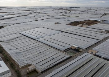
One thing I started noticing in my teens, and has worsened over time, is the limited variety of options. Don’t get me wrong, long supermarket corridors are colorful and filled with over 50 kinds each of bread, cereals, canned soups, chocolate, peanut butter, cookies, ice cream, potato chips, dog food, cheese analogs, frozen meals, and infant formula, but producers are usually no more than three, and ingredients often include things I wouldn’t be able to place in nature.
From those ingredients that sound natural, there’s one that troubles me and is present in all the food items mentioned above: palm oil, a main product from the plant called Elais guineensis Jacq.
Beyond the Package
Oil palm derived ingredients are found in food under many names: vegetable oil, vegetable fat, palmate, palmitate, palm stearine, or stearate acid. In cleaning products, cosmetics and pharmaceuticals, ingredients like sodium lauryl sulfate, glyceryl, cetyl palmitate, stearic acid, or palmitoyl are often derived from it too.
Healthwise, oil palm derived products aren’t bad, and are used to create nice textures in many items. Even more, palm oil is usually recognized as a renewable alternative to fossil fuels.
So you might wonder, why does this ingredient make you so angry? Are you simply an angry woman? Well, sure, and the world really needs more of us, but I’d also say we have to take all magical ingredients with a pinch of doubt.
That’s why I decided to dig deeper. Beyond my gut feeling or political instinct, I wanted to understand who actually stands to gain from this ingredient taking over our supermarket shelves, and at what cost. Was it improving the livelihoods of smallholder farmers? Was it driving local development, or merely feeding a system of industrial agriculture that thrives on cheap land, cheap labor, and even cheaper ecosystems? Those questions led me to look beyond the pretty packaging and start piecing together a bigger, messier picture that connected oil palms to deforestation and land grabbing.
Around 2018, in the spirit of making something powerful out of my anger towards the industrialization of agriculture and food production, and understanding the full chain of actors benefiting from this, I joined a group of people investigating oil palm in Mexico, on the ground and from space, using satellite imagery.
Hidden Costs
Around the world, oil palm’s high productivity and versatility have led to its rapid and consistent increase in demand and production. Plantations are productive for several decades, so they can be understood as long periods of steady, year-long income by farmers. However, this crop is also associated with high rates of deforestation, biodiversity loss, and significant social, environmental and health impacts to smallholder farmers due to the intensive use of agrochemicals and polluting oil extraction processes.
In addition, if you’re growing oil palm and at some point decide not to do it anymore, removing the plants is quite expensive – a 2012 study on Malaysian plantations estimated the cost of removing a hectare of oil palm at RM 34,500 (over USD 10,000 at that time).
Furthermore, when we talk about biofuels we usually forget to say that soil is not a renewable resource and, for this purpose, oil palm would most likely be produced as a monocrop in an industrialized way, a practice that does not regenerate the soil.
Initiatives like the Roundtable on Sustainable Palm Oil (RSPO) have been trying to regulate production and reduce these impacts, but many organizations have questioned their efficacy and standards.
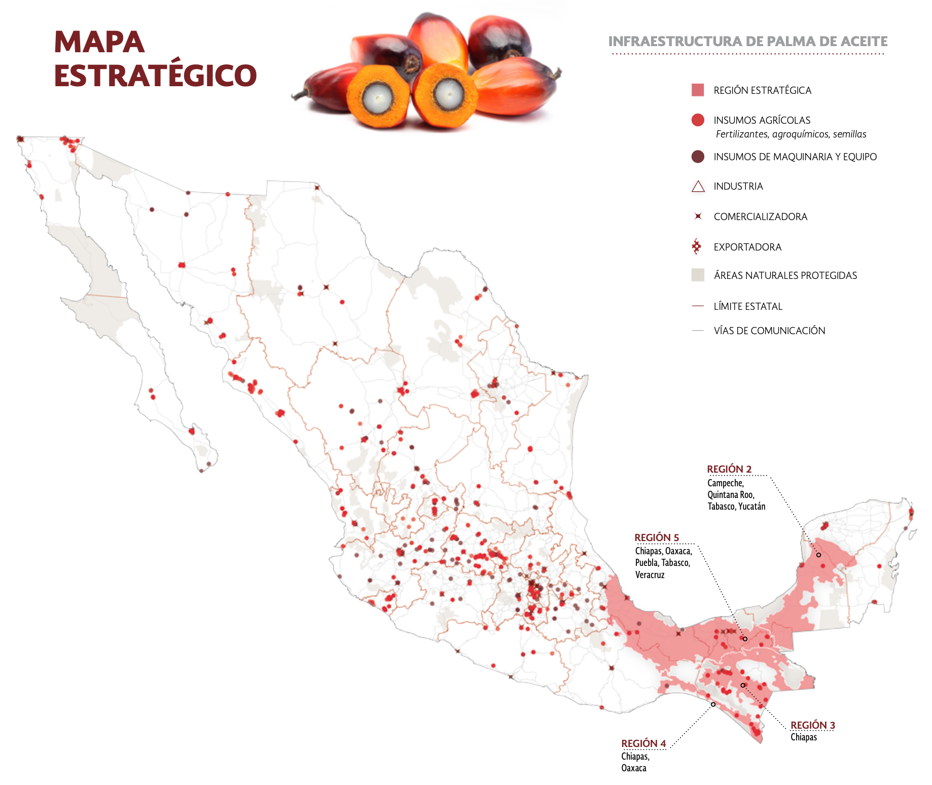
In Mexico, the first attempts to establish oil palm plantations began in the 1950s, but production and demand only took off in the late 1990s, when the government classified it as a strategic crop–a crop that’s highly competitive in the market and/or important for food security–and a series of policies were designed to promote its cultivation and commerce at the federal or state levels.
In 2017, the Secretariat of Agriculture and Rural Development (SADER) published the National Agricultural Plan for the Period of 2017 to 2030, where they included the recommended market strategies to increase production and satisfy domestic needs, and maps indicating which regions were agro-ecologically suitable for each of the 38 strategic crops.
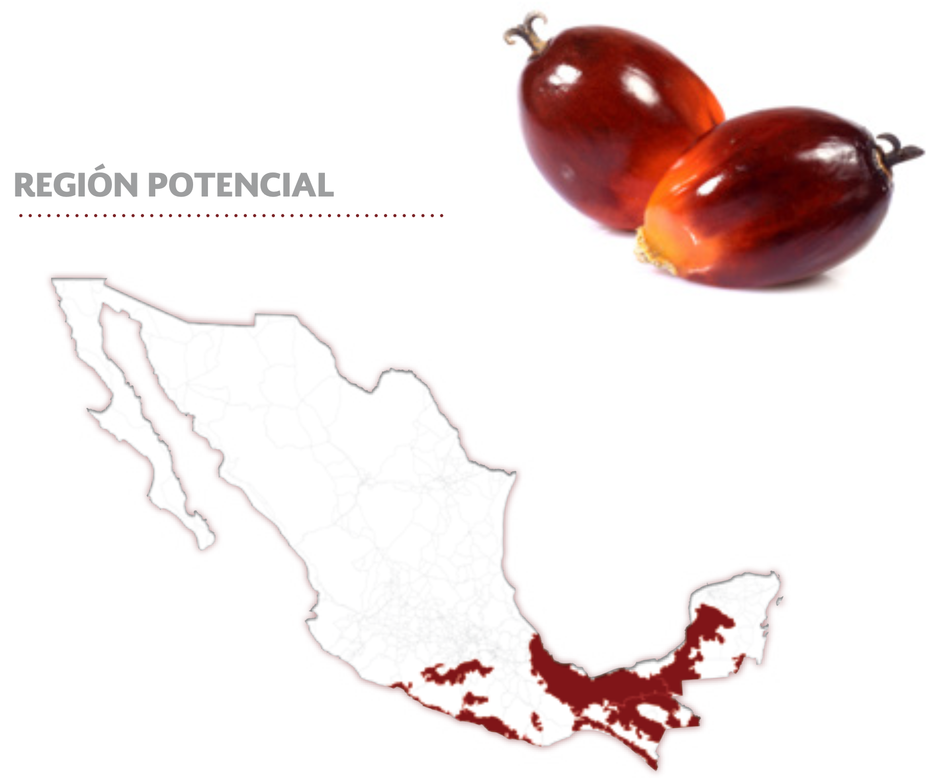
In the case of oil palm, the suitability map indicated that 14.2 million hectares of the national territory were suitable for oil palm cultivation, an area almost the size of Nepal.
Unequal Maps
The SADER’s suitability maps were based on maps from other institutions, like the Secretariat of Agriculture and Rural Development (SAGARPA), the National Institute of Forestry, Agricultural and Livestock Research (INIFAP), and the Institute for Productive Reconversion and Tropical Agriculture (IRPAT). Such maps are typically publicly available at very low resolutions and use different mixes of data climatic and topographic data (obtained from meteorological stations), edaphic characteristics (obtained from local studies), and cultivation areas (obtained from satellite data).
Observations of the Earth from satellite data, aka remote sensing data, have been used for the identification and analysis of crops of strategic importance, with the purpose of estimating their yields, preventing risks associated with climate change, and identifying socio-environmental impacts. At the moment, commercial satellites can return imagery with a resolution of around 30 cm per pixel every few hours, and software for satellite imagery management, like EarthExplorer or Google Earth have been accessible since the early 2000s, but high-resolution data is typically very costly and affordable only to large institutions and governments.
Although subscriptions and pay-as-you-go options are more affordable, publicly available data–more likely to be accessible to smallholder farmers–is usually provided at lower resolution, typically 5-500 m per pixel, updated from daily to every few weeks. Also, feature identification and classification can be done manually by humans or with data-driven algorithms to cover larger areas, but results should always be verified against on-the-ground data to avoid confusion between crops and ecosystems.
For example, distinguishing primary forest from oil palm data plantations is not a simple task. Manual methodologies are typically highly accurate, but unsustainable for large studies, which might explain why SADER gathered data from multiple institutions using different methodologies.
In any case, when agricultural policies rely heavily on remote sensing data, many issues on the ground are obscured, like the full breadth of environmental impacts of a crop’s cultivation, or the desired futures of those working the land. Even more, the lack of, or unequal access to, high-resolution data, raises questions about the adequacy and power imbalances promoted by those policies.
Follow the Data
In 2019, trying to understand the impacts of SADER’s recommendation of turning such a large amount of land into oil palm cropland, we decided to dig deeper into this topic. Afterall, we were city people and maybe farmers were very happy with their job prospects, or using palm oil derived products was the least impactful thing on the environment.
We contacted people involved in oil palm production, like the women farmer organizations “Agua y Vida, Mujeres, Derechos y Ambiente” and “Casa de la Mujer Ixim Antsetic”, and people in academia and the government, and we started looking at all publicly available information about oil palm production in Mexico. Despite abundant governmental data and scientific literature, it was hard to say who was benefiting the most out of oil palm production in the country.
We didn’t find any publicly available interactive map of oil palm plantations at the national level, which we thought crucial for smallholder farmers and other non-governmental policy-makers to contribute to the design of agricultural policies.
So we decided to create it.
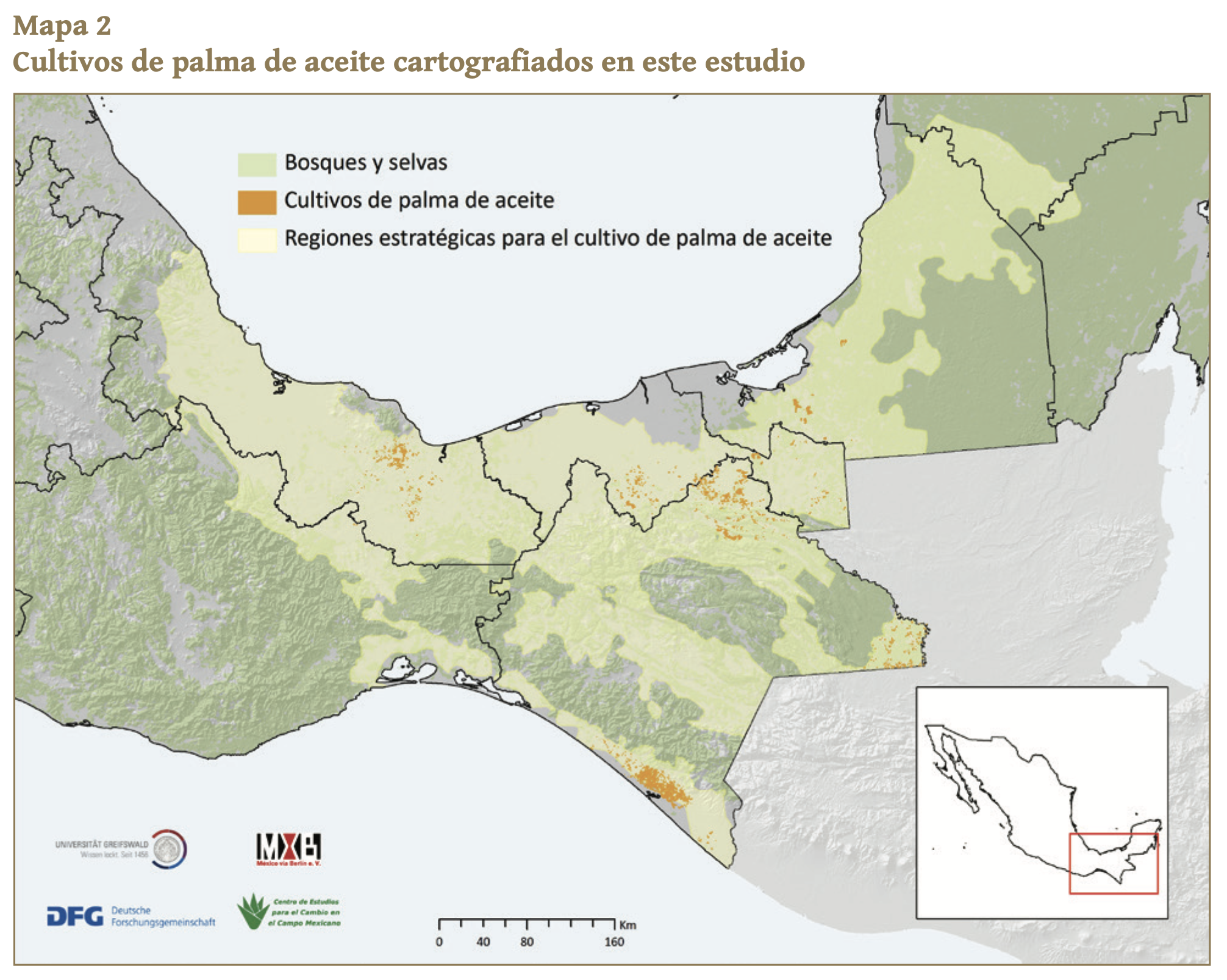
It took us two years of gathering and analyzing publicly available data on oil palm’s socio-environmental impacts, production and cropland from 2014 to 2019. We followed a semi-automatic remote sensing analysis methodology running Python scripts over publicly available Google Earth satellite images to create our publicly available high-resolution oil palm plantations map, and a report explaining our findings.
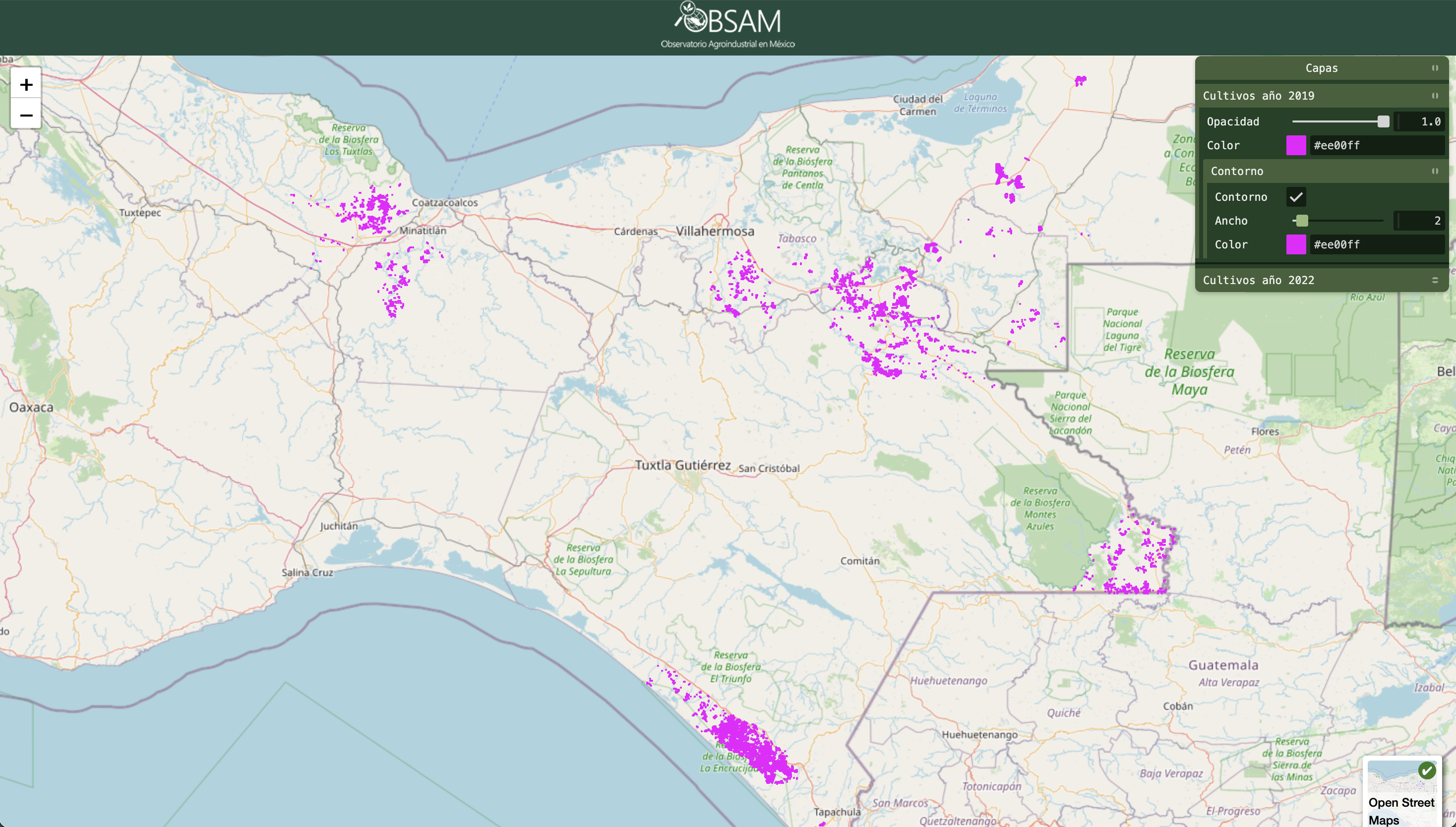
Considering the potential of these mappings, we decided to call ourselves the Observatorio Agroindustrial en México, or OBSAM with the aim of expanding this study to all the strategic crops in the country.
Our map showed the distribution and expansion of oil palm at the national level. The data had the potential for identifying spatial relationships with transportation and other infrastructure projects, other agricultural programs, or the coverage of governmental sustainable rural development programs.
Expansion and Deforestation
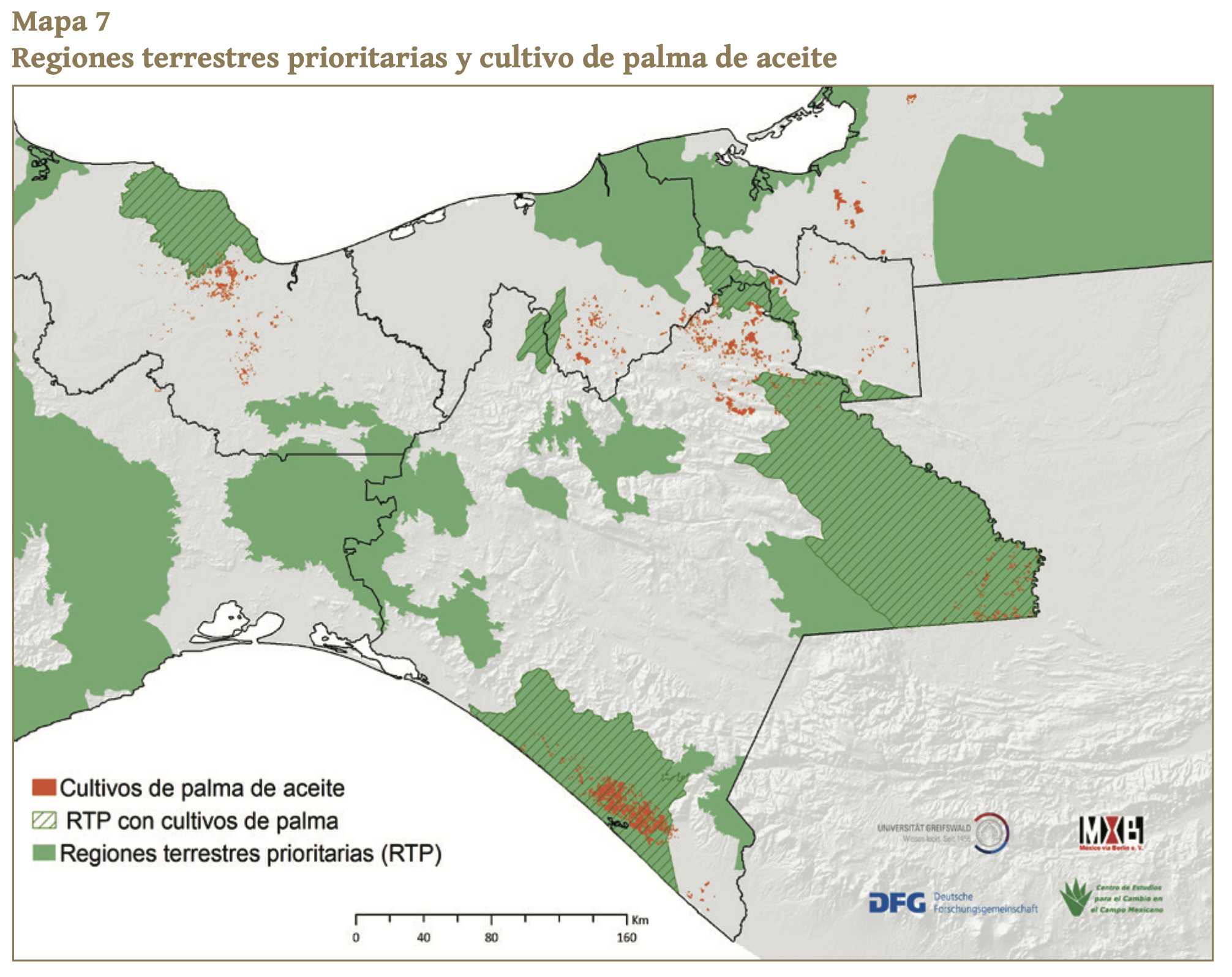
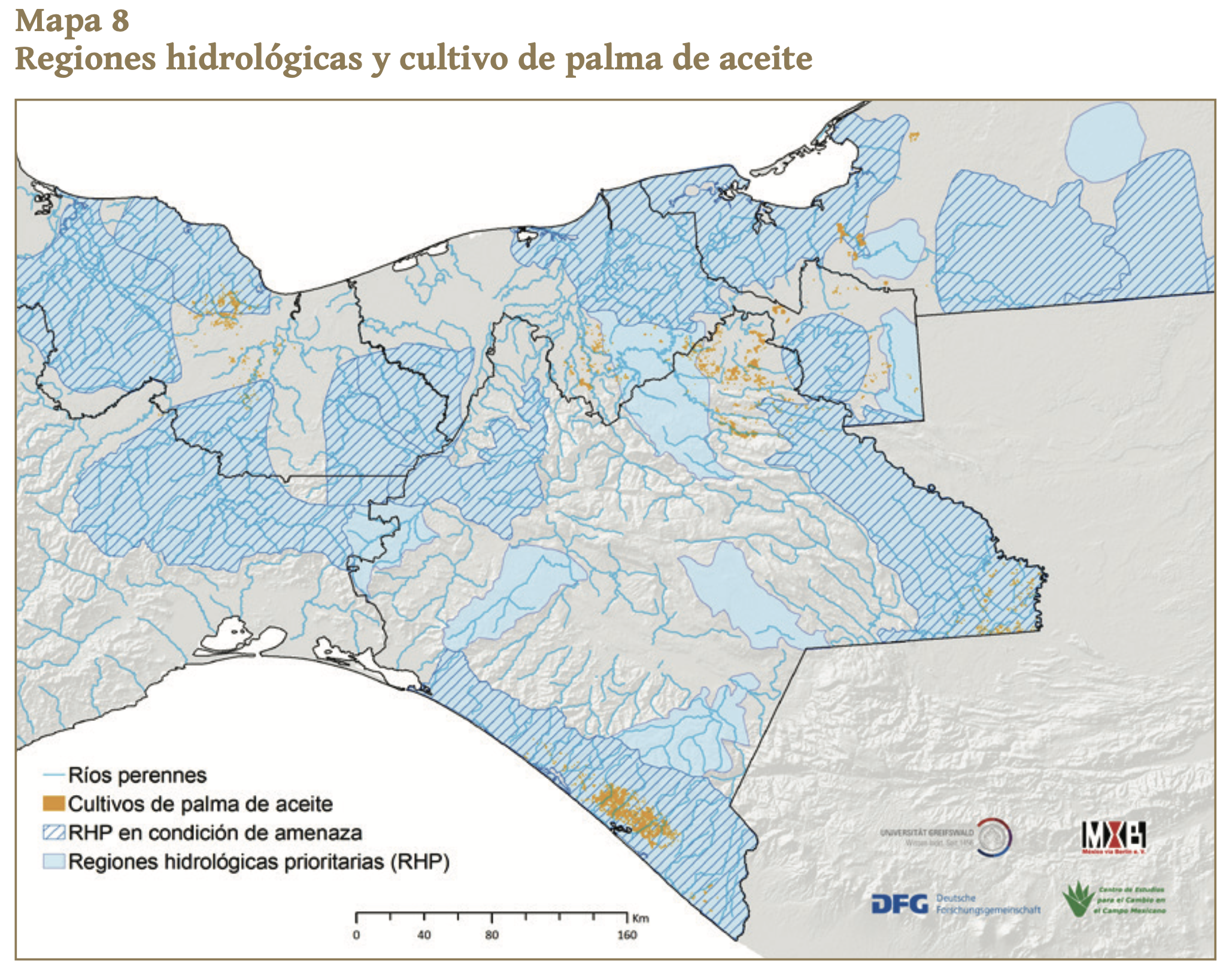
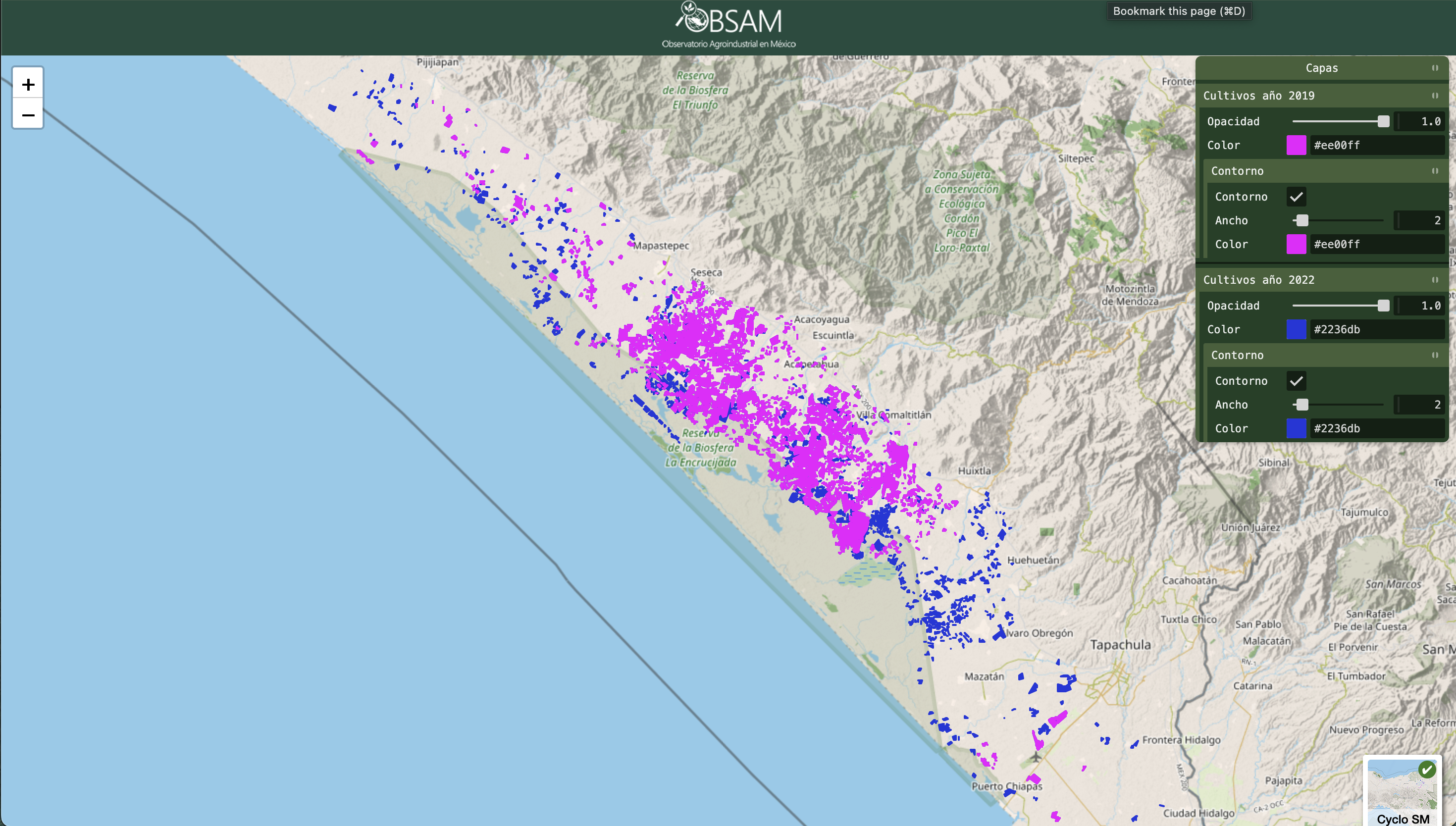
We identified 62,057 hectares (ha) of oil palm plantations, usually close to transportation infrastructure and areas of scrubland, rainfed agriculture, pastureland and secondary vegetation.
From these, 4,022ha were inside natural protected areas, mainly in the Palenque National Park, and the Encrucijada Biosphere Reserve (EBR) both in the Southern state of Chiapas–researchers, civil society actors, farmers, and media, had long reported this and asked for controlling the crop’s expansion in these areas, but no official response had been given to these concerns.
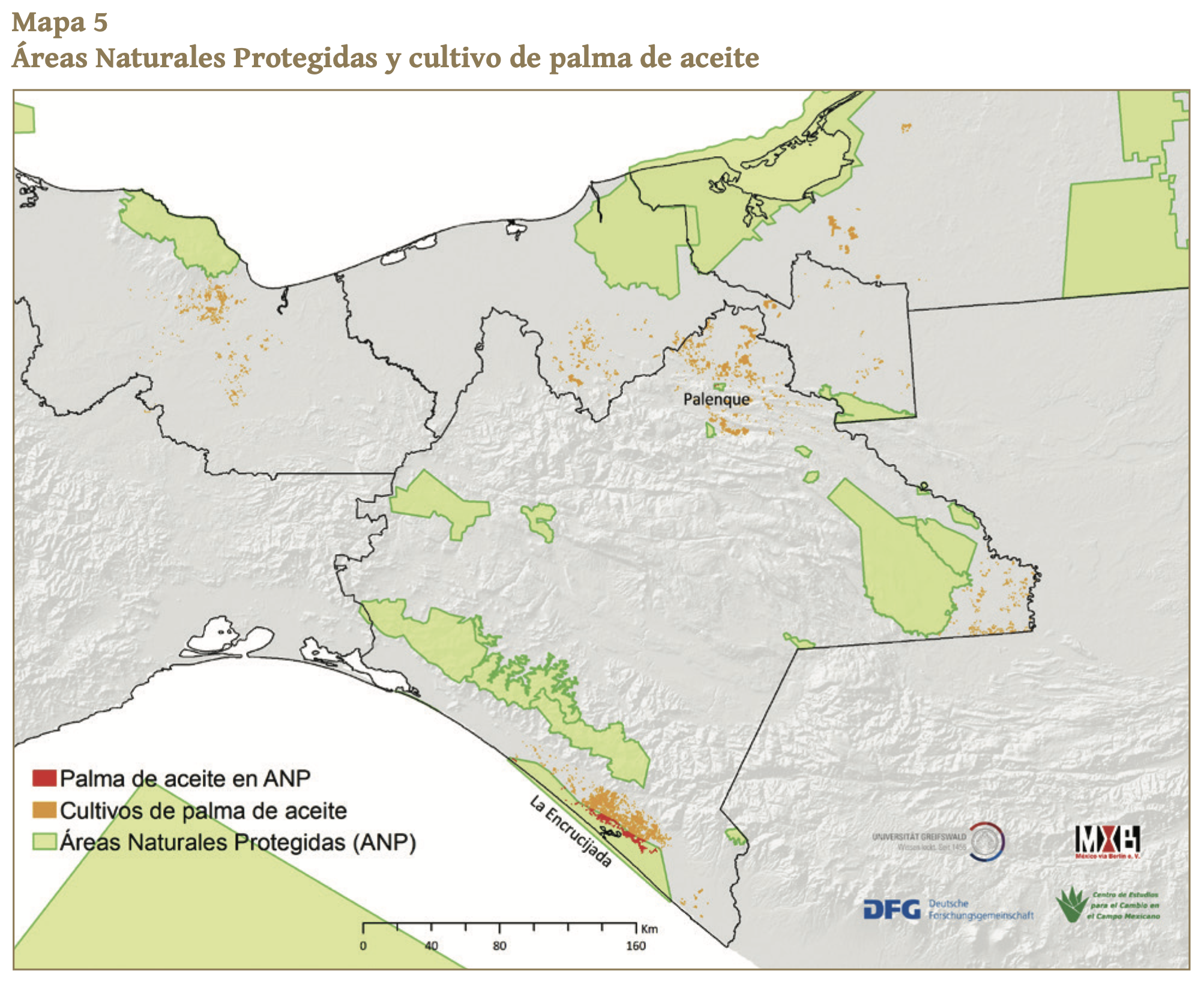
In addition, oil palm plantations were found in five terrestrial and seven hydrological regions of importance for biodiversity conservation, as defined by the National Commission for the Knowledge and Use of Biodiversity (CONABIO). Finally, comparisons against official data for forest cover from the National Institute of Statistics and Geography (INEGI) for 2017 and 2018, identified a link between oil palm and deforestation in more than 5,400 ha of forests and jungle.
Our literature review also showed that there were indeed multiple opinions about oil palm’s benefits and impacts around the world, depending usually on the level of access to technology and subsidies, labor force, land ownership, social organizing, and decision-making power of those who grow it.
In Mexico, technological requirements for its cultivation have led to the replacement of itinerant traditional agricultural methods, like roza-tumba-quema –an itinerary agricultural technique practiced in tropical regions for around 10,000 years where land is cleared (roza-tumba), burnt (quema) and then let to rest for a prolonged period of time, recently modernised to roza-tumba-pica (clear-burn-add organic matter) to prevent wildfires.
In addition, hard labor requirements have pushed women to do less specialized and lower income jobs, and the lack of a local market has led to economic dependency on gathering and extraction centers, which are not always easily accessible and typically private.
Even more, around half of oil palm production in the country was carried out by smallholder farmers in communal land, or ejidos, of less than 50 ha, which often exposed them to other impacts observed around the world: land concentration, foreignization and grabbing.
In 2018, the estimated revenue per hectare of oil palm was around MXN 38 (less than USD 2), but production was relatively profitable in places like southern Chiapas, where smallholder farmers are typically landowners and have created cooperatives and organizations that help them access governmental financial incentives.
Food Insecurity
So what kind of information, governmental policies and mechanisms would benefit smallholder oil palm producers, improve production, and limit social and environmental impacts?
Turns out that this was not a revolutionary question, and around the same time, the Food and Agriculture Organization of the United Nations (FAO) was also trying to understand this. In 2022, FAO found that around 37% of the world’s land was dedicated to agriculture and over 80% of farms around the world were under two hectares (20,000m2) in size. Such smallholder farmers produced around 35% of the entire world’s food, despite occupying only around 12% of all agricultural land.
The FAO highlighted the need for detailed data–Earth observations included– that helped understand regional differences in agricultural practices and production, so that policy-makers could design agricultural plans that aligned to the UN sustainable development goals (SDGs). These goals have the stated aim of bringing “peace and prosperity for people and the planet” by promoting sustainable production, improving the productivity and livelihood of smallholder farmers, addressing inequalities, and guaranteeing food security worldwide.
The FAO’s data means that 35% of food was being grown in around 4.5% of the world’s land by 2022. Although this might sound like our dreams of food security are easy to achieve, we have to be careful with our steps ahead because there’s a limit to how much of the world’s land is suitable for agriculture. Developing some suitable land might carry severe social and environmental impacts, and not all current agricultural land will remain productive in the future due to climate change and impactful land use.
Elusive Answers
As our findings proved the importance of carrying out the independent monitoring of this crop’s expansion, we decided to continue gathering and analyzing data to verify some impacts reported by multiple independent organizations. This way, in 2023, OBSAM published a second mapping with data from 2016 to 2022 and created a publicly available visualizing tool.
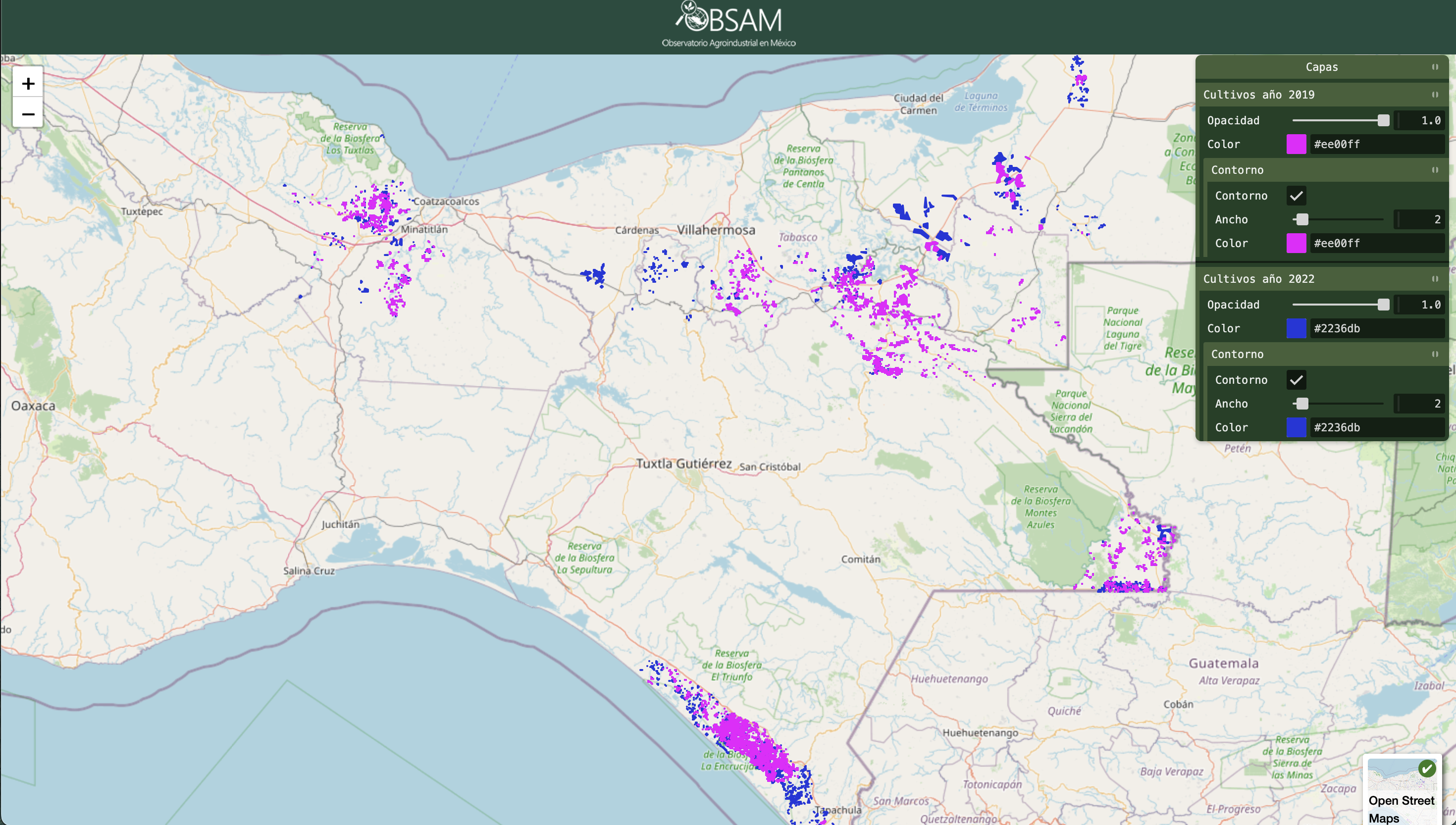
Our improved methodology detected 7,559 ha inside natural protected areas, mainly in the EBR and the Tuxtlas Biosphere Reserve in Veracruz, something that had already been reported by peasant organizations but not evidenced in existing mappings.
This time, to address the lack of verification in situ, the mapping was compared against publicly available data for the Lacandón Jungle in Chiapas, prepared by the General Coordination of Corridors and Biological Resources (CGCRB) and oil palm producers in the municipalities of Benemérito de las Américas and Marqués de Comillas, showing a large number of errors in the CGCRB archive. Comparisons against official data on forest cover now showed oil palm driven deforestation in 7,317 ha.
OBSAM is now expecting to release a third mapping with data until 2023, to enable the comparison between the three different mappings and identify new, growing and abandoned plantations, which would allow us to understand the paths of deforestation and land use changes.
We’ve also gathered infrastructure maps and contacted people investigating the corporate side of oil palm commercialization, so we hope to get closer to understanding its relationship with important infrastructure projects and which policies are benefiting which actors the most.
However, many questions remained unsolved and to analyze all strategic crops and offer alternatives to oil palm production we would need to develop closer ties with people in communities located in the vicinity of oil palm plantations, to understand agricultural practices and challenges, develop participatory mapping tools for verification of satellite analysis and identify other datasets to capture what is meaningful and desirable by people on the ground.
It is still unclear which existing agricultural practices and policies are benefiting smallholder farmers the most, but supermarkets continue to have more and more products containing palm oil derived products, so somebody must be making big profits and we would prefer it if it was them.
*If you want to support our work, or if you’re doing something similar and you want to share your struggles with someone in the same boat, full access to OBSAM mappings is granted under request. We are a group of people addressing data-access inequalities, and supporting smallholder farmers, academic research, and non-commercial enterprises. You can think of this as positive action in land observations and policy-making.