





This article is part of the dossier “Plural Archives, Cultural Practices, and Political Imaginaries in Syria and Lebanon” curated by Ettijahat. The article below is a summarised script curated by UntoldMag. The PDF of the entire essay can be downloaded here. You can read the original essay in Arabic here.
“All water has a perfect memory and is forever trying to get back to where it was.” – Toni Morrison
The Orontes Basin (Nahr al-Āṣī) is a transboundary river shared by the people of Syria and Lebanon. Originating in the Labweh area of Lebanon’s Bekaa Valley and flowing into the Mediterranean at the Gulf of al-Suwaydiyeh, the Orontes has long served as a lifeline for agriculture and fishing and played a central role in shaping the culture, values, and shared memory of local communities.
Over the years, however, the basin has faced mounting social and urban pressures: floods and drowning, water scarcity, widespread pollution, fragile dams, the redirection of its course, and even its conversion into a sewage conduit in some stretches. As economic and social conditions in the basin worsened, particularly in the early 21st century, the geographical memory that once anchored the region’s inhabitants began to fragment.
Wars, environmental degradation, and mass displacement events such as the drying up of river segments, have all contributed to the fading of practices once deeply tied to the river’s natural landscape. In response, adaptive strategies for ecological management have begun to take shape, rooted in sources of durability communities can still draw upon to navigate their changing surroundings.
This article tells the story of the ways and patterns through which people have crossed the Orontes Basin and the notable decline in the culture of river crossing in recent years. Its inhabitants developed diverse array of crossing techniques based on available materials and needs ranging from transportation and fishing to trade or simple discovery. These lived experiences have generated a wide variety of structural forms for navigating the Orontes, some of which may appear familiar, like the stereotypical image of a boating device, yet are in fact far from fixed. These forms continually evolve and adapt to the challenges posed by the river itself, as well as shifting political and economic conditions.
The river as a corridor of transformations
The Orontes Basin has long been known for its difficulty of crossing, an aspect that shaped how the basin was historically defined and even influenced the naming of the river itself. The name al-Āṣī (the “defiant” or “unruly”) is said to reflect both the river’s unusual course, i.e. running against the flow of other rivers in the Middle East, and its resistance to those who attempted to cross it throughout the ages.
The inhabitants of the Orontes Basin, driven by an unconscious impulse to contest the dominant image of the river, created and practiced diverse forms of mobility. In this way, the act of constructing methods for crossing became more than a functional task: it served as a living testament to the effort to overcome the river’s defiance.
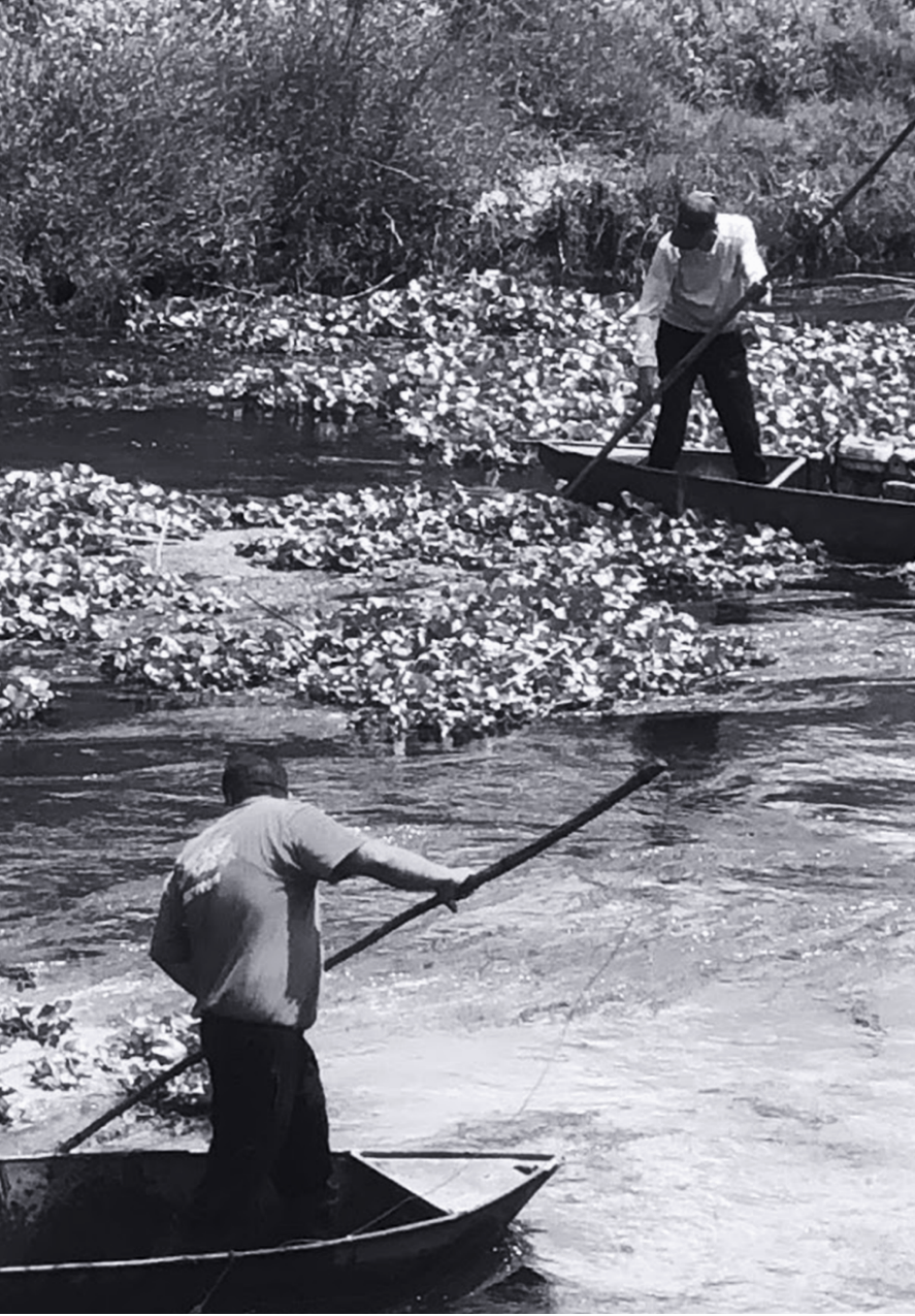
This dynamic has given rise to various written accounts describing forms of mobility across the river, whether as lived conditions or as described techniques. Among the earliest of these is Herodotus, who in Histories documented aspects of the Orontes Basin’s natural landscape, linking its geographical features to human experience. He described the river as difficult to traverse due to its unpredictable flow and natural barriers such as rocks and rapids, and pointed to the difficulty of communication between communities on opposite banks at the time.
With the climatic and social changes that have affected the river over time, the inhabitants of the Orontes Basin have continually sought to renew their interaction with its waters. Whether for transportation, fishing, or harvesting reeds, those living along the riverbanks have adapted to shifting conditions and harnessed the force of the river’s flow to meet their needs.
In a more detailed historical account of river crossings, Strabo noted in Geographica that it was possible to travel the Orontes from its mouth at the Mediterranean to Antioch in a single day. His account draws on various pieces of local knowledge of the river, and acknowledges that, despite its difficulties, there were successful attempts to navigate and cross the basin.
The enduring presence of skilled practitioners stands as evidence of the existence, transformation, and evolution of various crossing models over time. One of the most explicit testimonies was found in Darkush, a town in northwest Syria: a passage from a boat builder’s final homage to his deceased mother, dating back to 400 AD, in which he mentions his practice of boatmaking in bidding her farewell.
“In the year 400, on the twenty-seventh day of the month of Panemos, I, Eutyches son of Maron, boatbuilder, buried here my dear mother, Domitilla. Be brave, mother; no one is immortal”

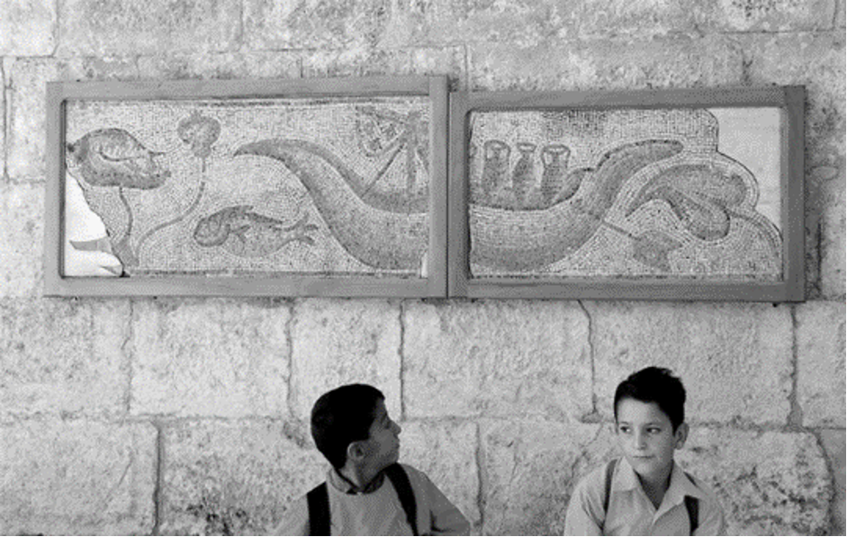
Within the same historical context, various models of river crossing emerged in the Hama region, characterized by a strong artistic dimension. A mosaic discovered in Souran, in the Hama countryside, depicts a boat with a single mast carrying four amphorae. Beyond its artistic and aesthetic value, the mosaic invites the imagination to consider the diversity of practices and the multiplicity of vessel types ranging from flatboats to mast-bearing ships.
The region of Antioch, situated on the banks of the Orontes Basin witnessed significant urban expansion following the defeat of the Persians in 333 BC and the subsequent control of the region by the Macedonian and later Seleucid empires. During this period, major cities, including Antioch, were founded along the river. As the city expanded, the concept of river-based mobility evolved in tandem, and the river itself became integral to urban development. The idea of crossing the river emerged as a foundational element in the successive growth of cities surrounding Antioch, aiming to facilitate communication and trade among them. River navigation thus became central to a wider process of urban development across the basin.
Later, the Romans invested heavily in the river’s surrounding infrastructure, resulting in the construction of several dams along its course, most notably the Roman dam that now forms Lake Qattinah, known also as Lake Homs. In the context of strengthening connectivity among cities along the basin, Roman authorities even considered altering the river’s course to facilitate access to various settlements along its banks.
Over time, such alterations obscured the river’s original features, making it increasingly difficult to recognize.
References to the types of wood found along its banks began to appear in the accounts of both Arab and Western travelers documenting transport across its waters. From this emerged a range of visions that imagined the boats on the Orontes as vessels born out of necessity. In the present, as the river no longer flows in certain stretches, the memory of crossing persists in the minds of its inhabitants, practitioners, and craftspeople, whether motivated by curiosity or functional, personal needs, rather than aesthetic intentions alone.
River crossing methods in the nineteenth century
Mobility along the Orontes River changed significantly in the nineteenth century, particularly with the growing interest and expanding influence of Western powers (chiefly France and Britain) under Ottoman rule in the Middle East.
This period witnessed a series of travel accounts offering varied descriptions of the Orontes landscape from the perspective of foreign observers. By the nineteenth century, navigating the river became a subject of curiosity and exploration for Western travelers, particularly the British, who were invested in developing water infrastructure to serve their imperial interests and to better connect the Eastern Mediterranean with India.
Among them was Parsons, who during his 1808 travels through the Middle East crossed the Orontes on his route from al-Suwaydiya to Aleppo. He described the river as unusually shallow compared to previous accounts:
“The river is so shallow that it is no longer navigable, as it was formerly, for boats of any size…”
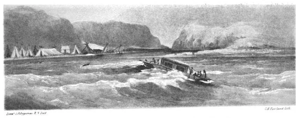
In a more detailed narrative, The Story of the Euphrates recounts the 1847 expedition of Francis Rawdon Chesney. Among his crew was James Fitzjames, who documented and mapped their path along the Orontes before the group departed northern Syria toward the Euphrates. In descriptions of the river scene at the Bay of al-Suwaydiya, year 1838, reference is made to the sight, and density, of mulberry trees covering the riverbed along which the boat was sailing.
“At the end of the Suweidiyah Valley, the Orontes River flows between steep, towering mountains, descending over a rocky bed, shallow in places, and completely unnavigable. The view is wild and absolutely beautiful… while the valley is rich in mulberry orchards, which produce in great quantity”
At the conclusion of Chesney’s survey, and based on findings from his second expedition, framed through a distinctly Orientalist lens, he proposed “cleansing” the mouth of the Orontes and opening a 67-mile canal between the closest point of the Orontes to the Euphrates, thereby enabling ships to navigate the river. In 1850, and despite the Ottoman Empire’s rejection of the plan, Chesney – an explorer and officer in the British army – was awarded the Royal Geographical Society’s Gold Medal upon the publication of these results.
Western expeditions to the Orontes Basin would continue throughout this period, driven either by curiosity or by strategic interests in investment and influence. Urban developments along the riverbanks played a prominent role in shaping the historical narrative of the Ottoman era, and were often foregrounded in records at the expense of local culture and traditional livelihoods.
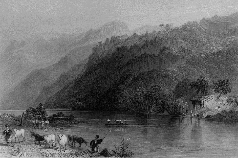
Following Chesney’s expedition in 1850, John Carne visited Syria in the late nineteenth century. In his book Syria, the Holy Land, and Asia Minor, he offered an account of crossing the Orontes based on the region’s urban and infrastructural development. He imagined Antioch as a vibrant hub of commerce and leisure, a vision ultimately dashed by the failure of Chesney’s canal project. Carne noted that had Chesney succeeded in opening a canal between the Orontes and the Euphrates, it might have rendered the river navigable from al-Suwaydiya to Antioch. Interestingly, Carne’s engraved illustrations include a depiction of a river ferry.
Orontes river crossing in the twenty-first century
Crossing practices are tied to the collective memory of the communities that lived them, whether through written accounts and records by earlier travelers, or through individuals within the local community whose names are remembered, often as practitioners or skilled experts.
The community remembers these artisans and the elders of the craft – known as shuyūkh al-kār – whose names are often associated with certain places or lineages, and who are frequently linked to other trades that rely on similar raw materials. One such example is ʿAbd al-Razzaq Abū Khusrayn, a well-known craftsman in the city of Hama, famous for building wooden nawāʿīr (waterwheels) in his workshop near the Saraya Bridge.
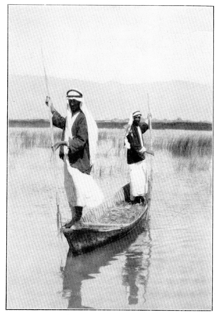
Radical changes in the surrounding environment have been central to the decline of river crossing as a living practice along the Orontes. From the 1930s until relatively recently, records show that wooden boating structures in the Ghab region were traditionally crafted using long-standing techniques. These handmade boating structures were once woven into the fabric of daily life and cultural exchange in the Ghab, a landscape shaped by the Orontes and known for its vast marshlands.
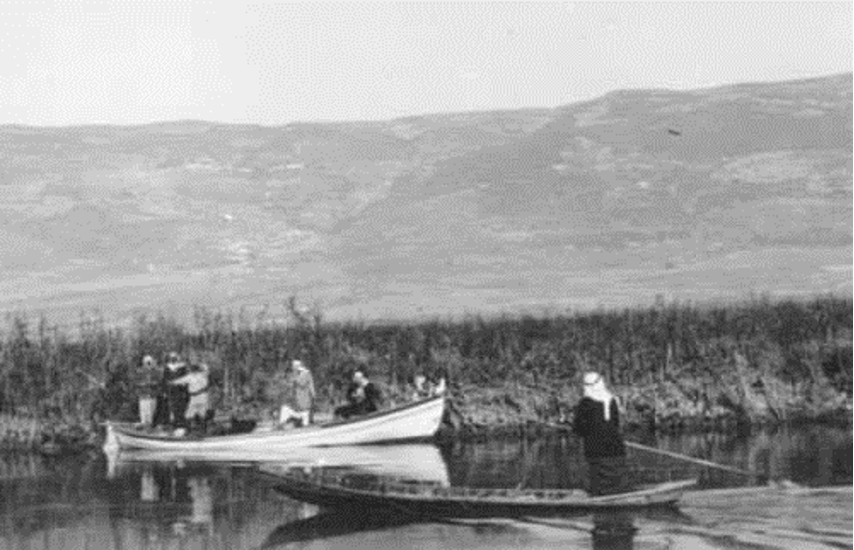
One of the most significant changes to the river’s course occurred in 1956, when a project was launched to reshape the region’s geography. The basalt sill at the lower end of the Ghab was breached, opening a channel that enabled the full drainage of the marshes created by the Orontes Basin. Between 30,000 and 32,000 hectares of wetland were dried and converted into irrigated farmland.
In 1969, this newly arable land was redistributed to farmers under the Agrarian Reform Law, with the aim of improving agricultural output and supporting local producers. While this transformation brought economic gains and boosted agricultural productivity, a visit to the river in 2021 revealed the fading of one of the river’s traditional subsistence functions – fishing. The gradual disappearance of fisheries naturally contributed to the decline of boatbuilding, a craft that had once been a recurring feature in the region.
Over time, the demand for wooden boats diminished, and the practice began to vanish from the region, leaving only traces of it in the collective memory.
“There used to be fishing boats on the [Orontes] River back when the water was plentiful. These boats were made specifically for fishing – not like the ones we see now coming from Tartous to transport people. We’re talking about wooden boats. They came in all sizes, starting from the smallest. Back then, the whole vessel was made of wood. Even in the time of Prophet Noah, as the Qur’an tells us, it was built from wooden planks, with dusur as nails. From the time of Noah all the way up to the twentieth century, boats were made of wood. Even now, they still exist. They’ve been replaced when necessary with rubber or metal, but no matter how much we try to move away from it, wood still carries a kind of spiritual weight. It still has meaning. Nothing really compares to wood.”
(A woodcraft practitioner when speaking about materials, May 2024)
Today, the Orontes Basin has become largely absent from public discourse among those living along its banks. This is due to the sharp decline in the usability and appeal of its waters which is scarce in some areas and heavily polluted in others. As a result, the river’s place in people’s living memory is increasingly relegated to the past, not only in spatial or physical terms, but in social and cultural terms as well.
“Sometimes I forget the river even exists… If you hadn’t asked me, I wouldn’t have mentioned it.”
(A 22-year-old resident living on the banks of the Orontes Basin, December 2023).

These forms of forgetting can be traced in changes to the practice of crossing. During a conversation with a resident of the al-Ghab region on one of his fishing trips in a metal boat, he recalled the wooden boats his father once used, and pointed to the disappearance of boatmaking due to the depletion of forest resources in the area. “There’s no wood like there used to be, it’s a lost craft now, really”. His words encapsulate the core reason behind the rapid transformations in spatial practices tied to river mobility and wood usage. This shift pushed fishers and farmers to either use lower-quality wood to build makeshift boats (resulting in accidents and drownings), or to turn to cheaper, more accessible materials such as metal or rubber. Even so, the practice itself has begun to vanish, as water flow continues to decline across much of the basin. River crossing is no longer a familiar aspect of daily life.
From poplars to rubber and iron
“Back then, we had poplar, eucalyptus, and willow. In the old days of the Orontes River, ever since the waters first entered from Lebanese territory, both banks of the river were lined with willows. I remember as a child, going down to swim in the Orontes… you couldn’t even see the sun. The willows from one bank met the willows from the other. They nearly touched.”
“That’s why we used to have so many willows around here. Willows grow on their own; they’re not planted. Same with poplars; they’re forest trees, like pine and cypress. All of them – poplar, cypress, pine, eucalyptus – are forest trees, and many are planted specifically for their wood. As for fruit-bearing trees like mulberry and walnut, those are the ones we use most in woodworking.”
(From an interview with a woodcraft practitioner, June 2024)
Forests have played a crucial role in shaping the character of its banks. Conversations with artisans who have inherited their craft over generations reveal that much of the wood used to construct boats and transport models was locally sourced from the orchards of Hama and Homs. Wood held more than just functional value; it carried embodied knowledge and local craftsmanship, especially in its role in enabling mobility.
Among the key sources of timber mentioned by today’s artisans were poplar trees, known for their fast growth and straight trunks. Poplars provided a strong, durable material, well-suited for construction. Reaching heights of up to 18 meters, they loomed large in both the physical landscape and the collective memory of the community, often described as lining the river so densely that their canopies covered the water entirely. Artisans also recalled using these trees to secure watercraft with locally made ropes. Poplars thrived in the orchards of Hama, particularly along the riverbanks and the edges of irrigation canals that cut through the agricultural fields. These areas, known as hawra, were previously dedicated exclusively to the dense cultivation of these trees, uninterrupted by other crops.
The dense foliage of poplar trees forms a natural canopy often used by farmers for raising poultry. Most orchards were once lined with poplars, and orchard owners had the right to harvest their wood for building transportation models and maintaining the waterwheels that irrigated their land. Today, with the responsibility for maintaining the nawāʿīr (waterwheels) transferred to the Hama Municipality, a dedicated grove of poplars was established near the iron bridge on the river’s left bank. These trees are regularly harvested to supply wood for the systematic restoration of the nawāʿīr. The tall, straight trunks of the poplars are especially suited for shaping the waterwheel’s arches, each one spanning half its diameter. Poplar wood, whether as planks or full logs, also remains a staple material in the construction of traditional Arab house roofs.
Practitioners have noted a shift in several dimensions of how materials are locally used. The first major change emerged with the decline of poplar and willow trees along the riverbanks of Hama and Homs, prompting a turn toward eucalyptus – a naturally less durable material for construction purposes.
Over the past decade, residents across the Orontes Basin have faced circumstances that required immediate crossings – driven by the need to escape danger or rescue loved ones. In such moments, people have improvised passage using unconventional materials and methods, including flexible rubber or makeshift metal structures capable of transporting many people, or quickly assembled floating devices built from household items. In these instances, safety is often sacrificed for immediacy.
Rubber, plastic, and iron now dominate the scene, favored for their availability, affordability, and durability to water exposure, and it was this shift that enabled people to devise new models of mobility.
The boat, the raft, and the hasakah
“The boats on the Orontes have become very small. There are two types: those made of eucalyptus wood, and others made from fennel. But the foundation was always wood.”
(Interview with a woodworking practitioner, June 2024)
Local practitioners shaped the traditional wooden boat through embodied spatial practices that resonated with the memory and environment of communities along both banks of the Orontes. Used primarily for fishing, the boat was one of the most familiar and widespread models of river mobility. However, the most significant transformation has been the shift from natural wood to iron as the primary construction material.
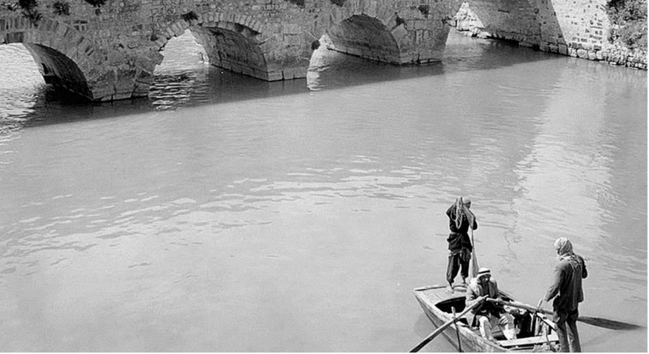
“All of them were found along the river in Hama, and sometimes in the surrounding countryside. But there were also types of wood they would bring from places like the monastery, for example. The hardest to work with was poplar. Poplar, walnut, and eucalyptus were the most difficult. Now, walnut is no longer available. We mostly rely on eucalyptus these days.”
(From an interview with a woodworking practitioner, June 2024)
In discussing the material used in crafting boat models, one practitioner noted that as wood became increasingly scarce along the Orontes, it was at times imported from other regions of Syria, most prominently Deir ez-Zor and the Ghouta of Damascus, to sustain the riverbank woodcraft traditions. By the end of the twentieth century, poplar branches, once abundant and pliable, had become rare. The tall poplar trees that had long formed the structural backbone of boat frames were steadily disappearing.
Today, wood has been almost entirely replaced by metal in the making of Orontes boats. This shift coincides with the river’s accelerated drying over the past decade, a result of climate change that has drastically affected the region, altering crop patterns and depleting water levels. Even modified versions of traditional boats have become increasingly rare. However, some individuals who still rely on fishing for their livelihood can be seen using the updated model: iron boats equipped with electric motors, now a common sight along the shrinking river.
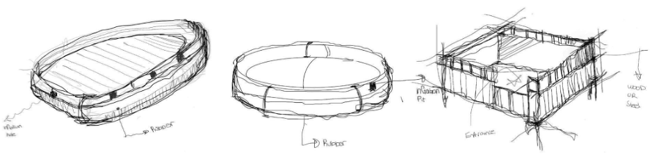
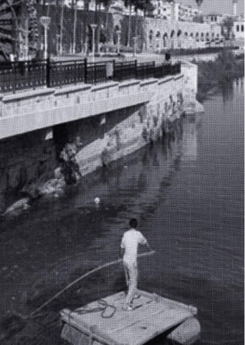
In response to mounting environmental and social pressures, residents have shown remarkable adaptability. Through trial and error, they developed makeshift tools and floating platforms that meet their needs. An example is an unconventional ferry and raft design, shaped in response to harsh environmental conditions and the narrow margins of available material. At its core is a wooden plank, which acts as the main platform upon which the user stands. The supporting beams, which are attached beneath the plank, do not follow standard dimensions but are adapted from whatever materials are available at the time of construction. Four barrels are fastened to the beams beneath the plank, enabling the whole structure to float. Navigation is achieved using a single wooden pole, often made from strong wood such as poplar or eucalyptus.
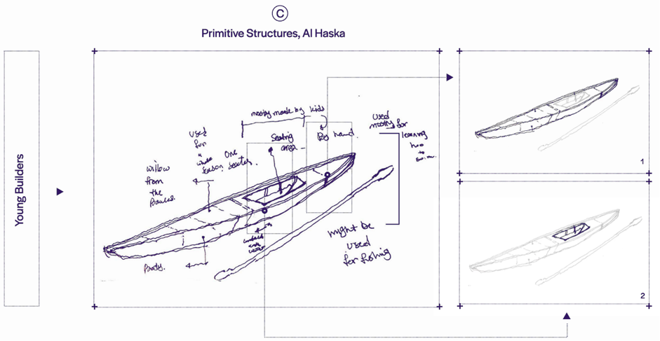
Another type of boat is the hasakah. The basic structure of the boat consists of a narrow body designed to provide stability on the water.
A shallow, carved-out area at the center offers a place for the young rower to sit, shaped to ensure balance during use, which is an essential design consideration for maneuverability and control. A simple steering stick, similar to those used in other models, is employed to direct the vessel. Through these boats, young builders are able to explore their environment and engage in a form of practical learning rooted in experience. The act of constructing and navigating the hasakah becomes a medium for understanding their ecological surroundings and connecting with traditional crafts. This model has seen little alteration over time. Its form has remained largely unchanged, not only because it requires minimal materials, but also because its primary purpose has always been recreational and educational. Unlike other forms of transport that have shifted toward metal or recycled components, the hasakah continues to be shaped from wood, which remains the principal material in its construction.
Across the various means of crossing the Orontes River, these three models (the boat, the hasakah, and the raft) differ in their methods of construction, materials, and form. While they share certain foundational elements, especially in structure and function, each embodies a distinct design logic shaped by environmental conditions, material availability, and use.
The boat is typically built by specialized craftsmen, many of whom have a background in woodworking or have worked on the construction and maintenance of waterwheels. By contrast, other models, such as the raft, are constructed by non-specialist users, often for immediate, practical needs.
The hasakah, meanwhile, is built by children and youth experimenting with rowing and engaging the river as a space of learning and play. They use whatever types of wood are available locally, and the model has remained materially unchanged over time. Though the hasakah has largely disappeared from the visible landscape of the riverbank, it continues to hold a significant place in the collective memory of the Orontes Basin’s riverine communities.
Collective memory
In communities formed around rivers, collective memory is closely tied to the local knowledge that emerges from daily interaction with the river itself. The environmental and climatic changes experienced in the Orontes River region, particularly in recent decades, have directly affected local knowledge tied to river crossing methods.
The collective memory is reflected in various written accounts, with some attributing boatbuilding to personal identity and others framing it as a challenge to be overcome. As the river became a site of exploration, such writings began to describe it from diverse vantage points: natural and geographic inquiry, expansionist ambition, or orientalist projection. Through these lenses, the crossing of the Orontes has been depicted across time and into the present. This memory trail helps illuminate the evolving relationship between people and their environment.
The decline of vegetation cover and the disappearance of key natural resources have altered the materials and techniques used in boatmaking, resulting in changes to both structure and use. In response, hybrid models have emerged, adapted to new conditions through the use of substitute materials or the repurposing of parts from older vessels. Different models used to cross the river speak to the relationship between environment and local knowledge – from the origin of materials used, to the function each model was designed for, to the modifications shaped by shifting conditions.
However, these transformations were not purely technical. They carried social and cultural weight, as some practices faded from daily life and shifted into the realm of collective memory. Certain methods are no longer in use, but remain alive in oral histories and family stories, having marked their symbolic role in shaping the spatial and cultural identity of river communities.