


A new advent of Israeli psychological warfare appears to be creeping into the satellite ecosystem. Since the new Google Earth aerial update earlier this year, numerous users have revisited the Gazan landscape for a post-war glimpse. Reddit started to react to the images as well on multiple communities. Only with an accumulated anger and staggering sense of loss, would one be compelled to see what Israel left behind its genocidal project in Gaza. Buildings that were once local Gazan favorites turned into debris, preparing for something much more sinister.
For those unfamiliar with how such updates operate: Google Maps and Google Earth update their satellite imagery on a sporadic basis. Some updates take weeks, while others fall years behind real time. The conduction of such adjustments to the Google platforms are largely influenced by a variety of factors, such as global interest and humanitarian urgency in times of crisis.
Shortly following October 7, 2023, Google Maps updated its aerial images of Gaza twice. The first wave rolled out in November 2023, right after the first ceasefire was brokered and implemented in Doha. The 4-day truce, included the release of 50 Israeli citizens by Hamas and 150 Palestinian prisoners held hostage under administrative detention in Israeli custody. Following Hamas’ opposition to the terms of a proposed second truce, Israeli strikes on Gaza resumed more intensely, and by the end of December 2024, Gaza’s aerial images were updated on Google Earth for the second time.
It started with a curious tapping around on some buildings spotted as I zoomed in on “Gaza Strip”. The first dropped pin read منزل عائلة ابو حجر “Abu Hajar’s Family Home”. There was an absurd air to it; have families in Gaza always labelled their homes so publicly online? The buildings still appear intact, as opposed to a Damage Assessment Report conducted a year ago by UNOSAT, which states 66% of buildings in Gaza being decimated by then – more recently in April this year, the UN estimated the number at 92%.
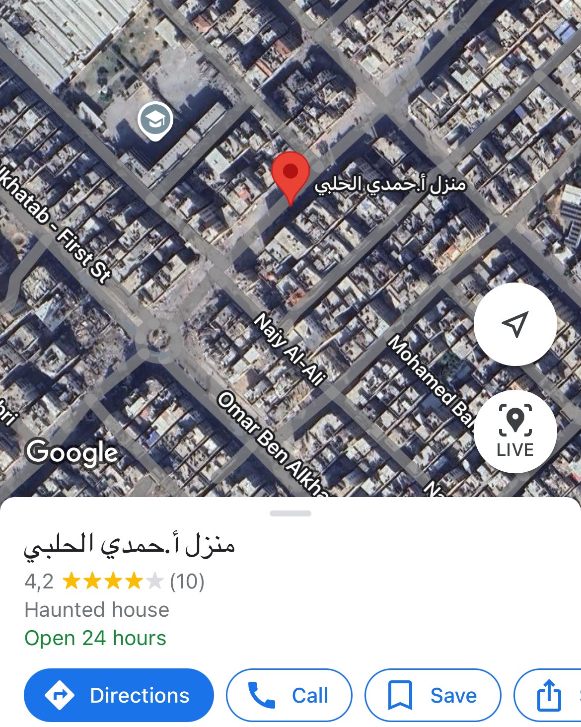
My suspicion deepened as I paid closer attention to the next detail: the location was categorized a “haunted house”. Happenstance? A technical bug?

This can’t be. As I dug deeper, I found similar cases elsewhere. “Haunted houses” started appearing across the maps of Gaza.

At this last location in particular, some activity was tracked from another profile follower – referred to here as “HH”- who commented “اخر رواء” in Arabic (“very chill”) under the location a year ago, during the war.
Curious to know what was behind the timing of the comment, I continued the search and clicked on HH’s profile. Their Google Maps profile revealed another follower under the name “SS”. After clicking SS’s profile too, it was linked to only one follower, anonymized here as “A”, which was not mutually followed back by the account named under “SS”.

The profile was traced back to this finding of a person in military attire. When further observed, the user showed frequently visited locations outside Gaza- such as the National Sports Complex in Kyiv. While it could be premature to assume the potential presence of external participants on the ground in Gaza, the discovery of such profiles around the pinned locations raises many questions on the reality of the war on Gaza.

While the identity and status of the individual in this image remain unverified, preliminary indicators suggest they may be an Israeli soldier operating on the ground. In parallel to the categorization of civilian infrastructure under “haunted house”- a term trivializing genocide – this behaviour represents yet another twisted game played over the bodies of Palestinian families.
This phenomenon is synonymous to preceding incidents that happened during the first wave of Israeli attacks on southern Lebanon in November 2024. A few Google reviews were posted by Israeli soldiers, mocking demolished landmarks and clearly highlighting their criminal territory.

Under a genocide, it is impossible to be bound by assuming the worst; but also acknowledging real practices carried out in a material manner. It is also beyond comprehension to imagine imported sadism infesting what was once home to multiple Palestinian generations. However, while these homes are labelled as “haunted houses”, their satellite images depict them without visible damage, perhaps hinting at the displacement of the families that once lived there.
Common threads in military theatrics
Drawing parallels between various ongoing conflicts via satellite imagery has sparked an arena of discussions. Through a speculative piece published by FAZ in December 2023, Gregor Grosse questioned the role of Google Maps in suggesting military tactics to participating units in Gaza and some parts of Ukraine. Moreover, some satellite images from Mariupol have been retrieved by The Guardian only a year following the Russian attacks on Ukraine – with the destruction documented in greater detail and proportion.
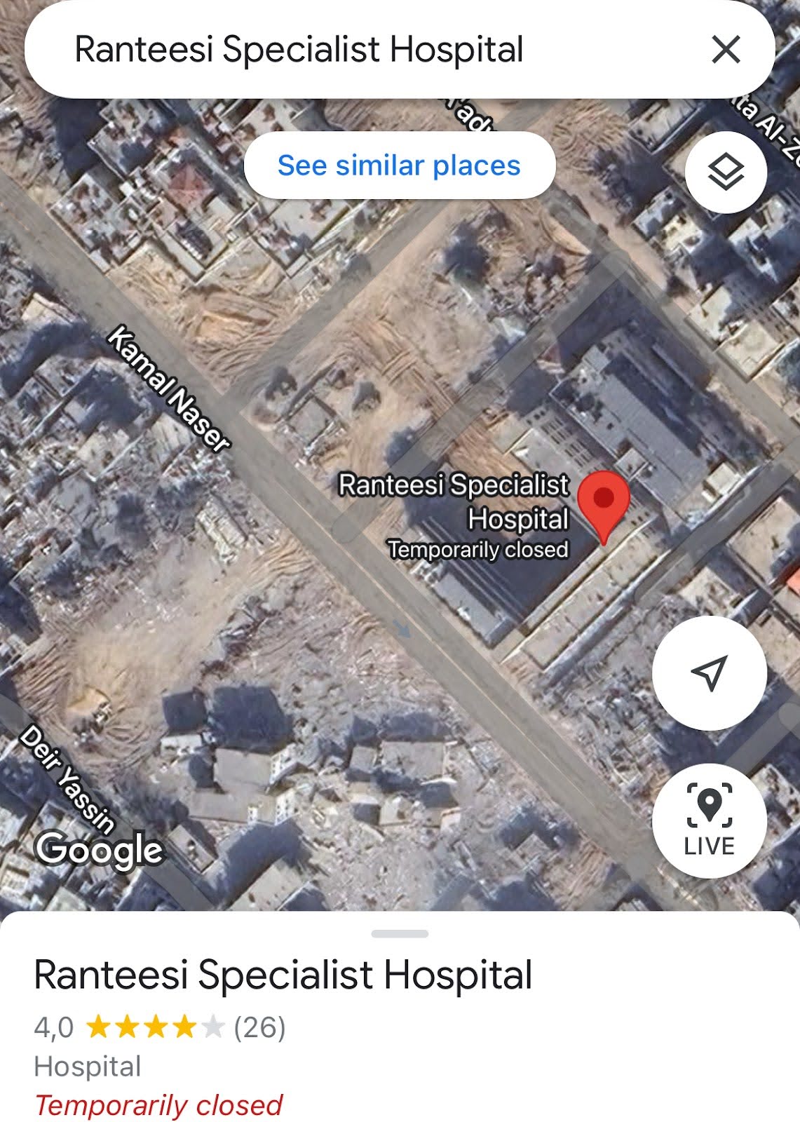
On the other hand, another part of the satellite visual landscape starkly reflects the ongoing devastation in Gaza, capturing plumes of smoke rising from bombed-out buildings. At Al Ranteesi Hospital, the destruction is especially evident—the facility is marked as “temporarily closed,” surrounded by debris. It is likely that beneath the rubble lie victims who never made it inside for care, as the hospital itself is no longer operational.
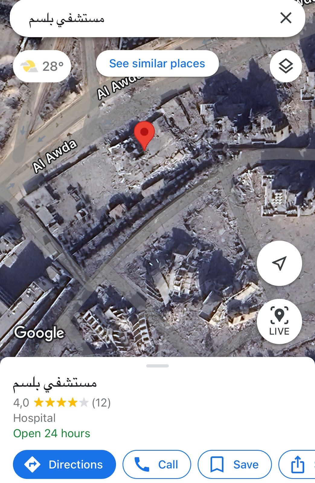
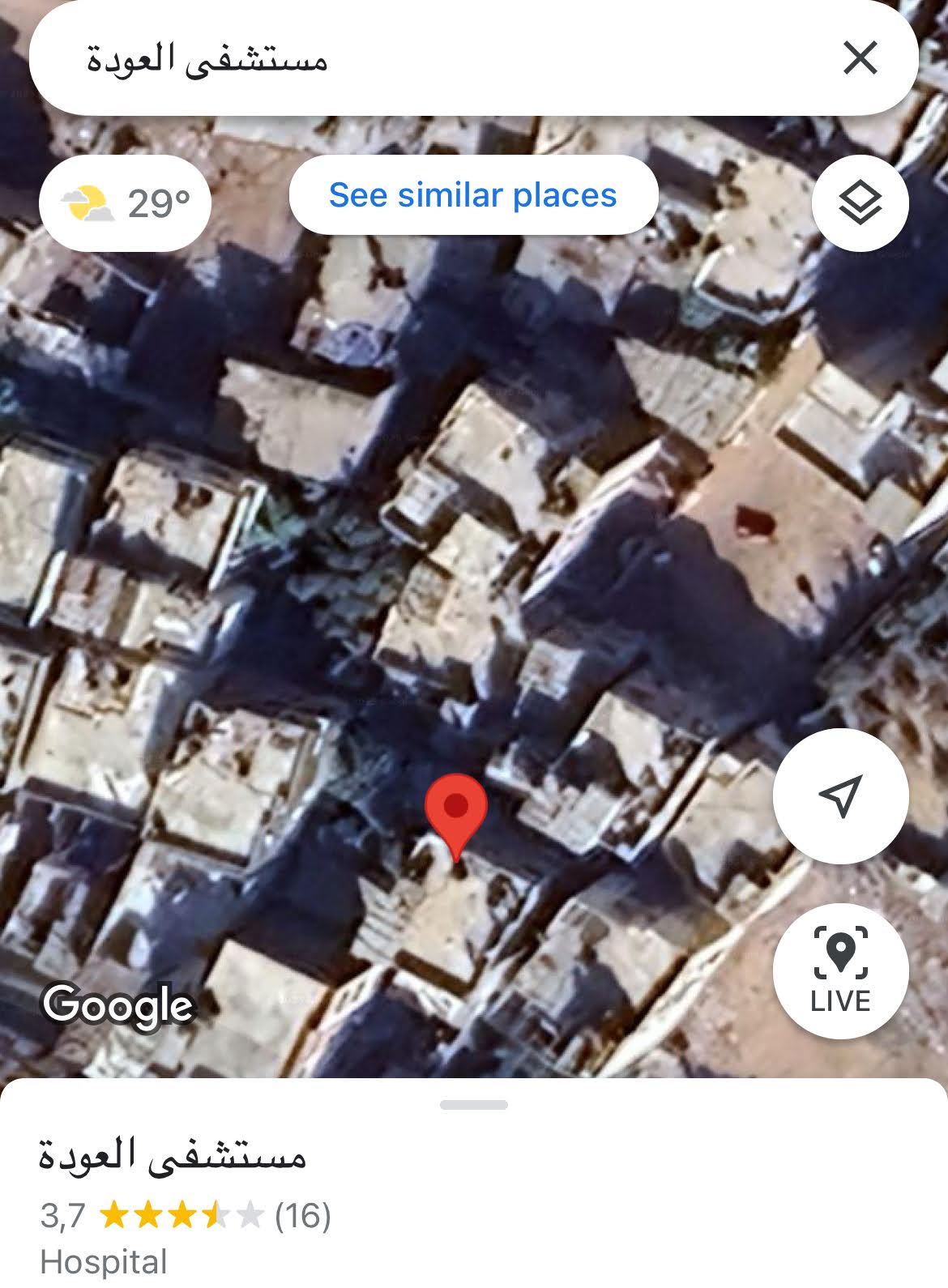
Moving to Al Awda Street, Al Balsam Hospital displays a similar scene, with rubble around its site – but showing an “open 24 hours” sign. Similarly is the case of Al Awda Hospital, which was besieged by the occupation forces during the early days of the war, and resumed its operations again as of May 2024, reported by the Institute of Palestine Studies and classified as “partially functional”. As of May 2025, Al-Awda Hospital was ordered to close by Israeli authorities – marking the closure of the last health facility in northern Gaza. Its halt in operations came in line with the start of a full aid blockade on Gaza; replacing it with an even more lethal alternative – aid from the mercenary-led Gaza Humanitarian Foundation.
In contrast, Al Shifa Hospital – which was left completely in ruins after Israel withdrew its forces, appears completely functional on satellite. The siege on Al-Shifa started around mid-November 2023 following the Israeli government falsely claiming to have found a Hamas base within the hospital infrastructure. During the encirclement, it was reported that around 1,500 patients and 15,000 displaced civilians were taking shelter within Al Shifa’s medical complex. Israeli military attacks left over 100 dead bodies buried in a mass grave during the siege. Al Shifa was one of the many hospitals bombed by Israel, followed by the Indonesian hospital in northern Gaza.
While mass graves have previously been identified with satellite imagery in different geographical contexts, such as Mariupol in Ukraine, this was unfortunately, and much unfairly, not the case for Gaza.

Whether such labellings and inequalities in cartographic documentation are intentional, is still a matter under investigation. Pioneers in this field of investigation include the works of infographic designer Marco Hernandez, who is currently working on visualizing the Ukrainian war and developing a system to help analyze the images from Gaza as well. The proliferation of such research underscores an urgency to critically envision a democratized future for evidence archival.
As colonial modern warfare festers into our geographical “cartosphere”, digital maps persist as manifestations of modern structural power and imperialistic practices. Here, a collective obligation arises for the international civil community to critically reflect on the exploitation of cartographic authority in relation to technological hegemony and political complicity. Its extensions provide an expansive leeway for legitimizing occupation, strategizing it, and to be creative with it too.
Your donations allow us to commission content like this.
Be part of the UntoldMag community:
Technological imperialism in the realm of genocide
With Web 2.0’s user-generated nature stemming from informational decentralization, it is only predictable that we are witnessing the wild west of the internet. Apart from spatial colonization via aerial manipulation, the Israeli occupation has historically resorted to the use of digital apparatus to spread its settler colonial agenda. Researchers Jamal Abu Eisheh and Shahd Qannam examine Israeli tactics of digital colonization through three pillars: physical surveillance, digital mapping, and social media.
Within this scholarly context, one of the frequently observed phenomena in Gaza is the use of telecommunication control by Israel to “warn” families to evacuate “areas of risk” prior to bombing residential infrastructure. The Israeli army even displays this tactic publically on their website as a measure to “minimize harm to civilians in Gaza”.

Israeli surveillance over the Palestinian mobile and wireless ecosystem has been prevalent since the early 2000s, following the Oslo Accords. Gaza’s telecommunication structure has already been severely impacted by economic sanctions since its 2008 siege, and even further destroyed since the 2023 war with 75% of the total 841 towers destroyed.
Since artificial intelligence is becoming rapidly weaponized for military competence, Israel was one of the first governments to implement AI technology to impose further surveillance on Palestinians. In the West Bank for example, facial recognition systems are used at checkpoints and through CCTV technology to track Palestinians and maintain their biometric data. This allows Israel to build a comprehensive database called Wolf Pack which enables Israel’s full control on the movement of Palestinians throughout the Occupied Territories.
In Gaza, recent applications such as Lavender AI have come to light. This data collection tool is supported by a “kill list”, which is designed to target suspected militants on the ground in Gaza – resulting in the systematic killing of entire families.
What we are currently witnessing in Gaza is not only beyond dystopian imagination – but a disturbing reality previewed before our eyes on the depravity of Israeli settler colonialism. Backed by the U.S. and other foreign allies, Palestinian lives are quantified through a combination of territorial isolation, militarized tech, and silent complicity of partner Arab states. Acknowledging the latter reasserts the urgency of decolonization on the technological front as a material necessity leading us to the project of Palestinian liberation.